89: Ice Age Keepsake
B L O C K I S L A N D, R I
 |
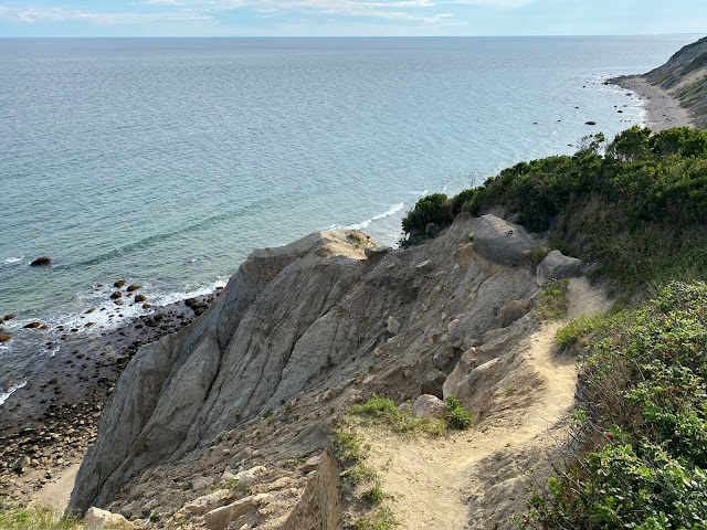
| Second Bluff, Block Island, Rhode Island |
The sandy path I’m following ends at the end of an era. Fifteen thousand years ago, this path would have been underneath a glacier, but when the Ice Age ended and that glacier retreated, it left behind piles of ground up conglomerate forming a string of well-known east coast islands including Nantucket, Long Island, and where I’m walking: Block Island, Rhode Island.
This path terminates at a bluff high above the Atlantic on top of that sand pile left behind by the Ice Age. It’s a pile at war with the sea. Incoming waves have been chewing away at the conglomerate for eons creating Block Island’s iconic Mohegan Bluffs.
To the east of where I stand is the more popular access to Mohegan Bluffs, complete with parking lot, kiosk, placards, safety railings, and a long staircase leading the base where those chewy waves are at work. But the path I’m on is off that beaten path – a much lesser known one that most others don’t take. And late on a Monday afternoon, it’s even less beaten having no other visitors except my four-person gang. We have what the locals call Second Bluff all to ourselves.
The trip from Virginia to get here was carefully planned; albeit hampered by a late start exacerbating the logistical challenge. First was finding the right dates around work and jury duties, but then came the coordination of mainland lodging, ferry schedules, and moped rentals. Plus, hours of island studying to make the most of our time… which kept us mindfully prepared to find spots like Second Bluff at the ideal moment and day.
Block Island is impressive. Measuring a mere seven miles by three, twelve miles off the mainland, it’s a biodiversity hotspot providing habitat for many plants and animals that disappeared from New England decades ago. As such, nearly half of the island is in permanent conservation protection. And a significant amount of that protection comes via The Nature Conservancy (TNC) at places like Rodman’s Hollow, Clay Head, and where we visited yesterday – Hodge Family Wildlife Preserve.
Hodge symbolizes the two driving forces that brought our gang to the Block. The first is the Glass Float Project which essentially is part scavenger hunt and part interactive art enticement. Each year 500 glass floats are hidden on the island by artist Eben Horton. It’s become a tourism boondoggle for the island, and a finders-keepers gift for float hunters. Many come to the Block and fail to find a float; however, in the first of many travel-magic moments on this island, we find one within fifteen minutes.
The second driving force is a continuing quest to visit one hundred TNC properties. Hodge represents number eighty-nine. Of the eighty-nine, those that came with similar logistical challenges often bear the best fruit. Places like Great Wass in Maine, Love Creek in Texas, or the Mesoamerican reef in Mexico were not easy to get to from Virginia but amazing additions to the collection.
Beyond finding a float, Block brought other travel magic; most of which came via sparklingly brilliant weather. Simply moving about the island at the slow breezy pace a moped affords was magic enough. Throttling around the Block, especially on the west side on an uncrowded Monday, was enchanting. The furthest-west spot we reached was Dory’s Cove where I watched plovers and sandpipers battle in their foraging quests among a beach of round stones glistening in the late afternoon light.
 |
| Dory's Cove |
 |
| Semi-Palmated Plovers |
Other magic came yesterday at Hodge. We followed the trail to its end at Middle Pond where on the far shore floated two Mute Swans – a Renoir-like idyllic a scene. Yesterday also, at the edge of Sachem Pond after poking through the tall phragmites, a large flock of Great Black-Backed Gulls across the pond were revealed. Another Renoir moment.
 |
| Mute Swans |
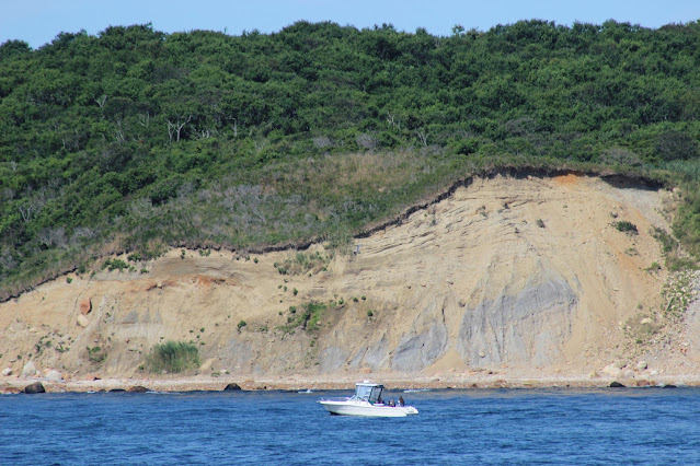
But one of most lasting and geologically telling views came via our arrival into Old Harbor where there’s an up-close view of Clay Head cliffs. Choose a starboard seat to not to miss this show. Clay Head looks like an open wound with the island’s inner soil layers on full display. Like Mohegan Bluff, the wave action keeps the wound open and constantly changing. It’s a dynamic first impression, but more so for geologic nerds like me, it’s the first hint of this island’s origin.
 |
| Clay Head Cliffs |
As I stand at atop Second Bluff late on our second and last day on this amazing island, I spot the spot from which my keepsake was gathered yesterday. A Block rock - a mere acorn-sized stone, but one that tells a grand story. Plucked from the rocky beach as far out as I could dryly scamper between incoming waves. Long ago, this keepsake was underneath a glacier being ground, scoured and then left behind by an Ice Age. At some point, the surf undercut this rock’s base and it tumbled into the sea from where I plucked it. It’ll spend the next few years in a dry office on display with keepsakes from other adventures. It’ll rest erosion-free under florescent lights and controlled temperatures until its next chapter begins after my retirement.
After two full days of exploring Block Island, and after months of researching, it’s clear why TNC labeled it one of the twelve Last Great Places. In the 1990’s, TNC rallied the conservation troops with its call to save great intact ecosystems vital to natural diversity in the United States. Being declared one of twelve Last Great Places is a strong moniker considering how many other amazing places adorn this planet. But when measured on geologic and biodiversity scales, and by travel-magic opportunities, it seems a more-than-appropriate label for this incredible and well-protected island.


I’m glad that you liked Dorry’s Cove. BI has a single source aquifer. Much of the Bluff erosion comes from groundwater bubbling up into the many tug ponds (peat) and then popping out down the bluffs.
ReplyDeleteThanks for that additional info about the bluff’s erosion. Very interesting.
ReplyDelete